The efficacy of a transport network relies strongly on infrastructure and scheduling. The ACT 2016-17 budget lays a bold plan for the future of public transport in the capital. With infrastructure spending in the millions, Express aims to produce an optimal schedule to improve reliability, reduce delays, and minimise load.
Think of this as a way to get more bang-for-buck in your infrastructure spending, or making your network better for free. Express can even simulate, test, and optimise your network (including rail) before it is built and make suggestions to improve it.
For each new bus we can save from purchasing by properly utilising the others yields a saving of $500,000 AUD + maintenance costs.
We can simulate the dynamics of a network using only the timetable in GTFS (General Transport Feed Specification). We reproduce the topology of the network and run dynamical agent-based models of the public transport system. At this point, application of any statistical model may be applied. Using a simple statistical model of average delays, we are able to reproduce the observed 'bunching' of buses in key problem areas.
From the (static) GTFS data alone, our framework can produce an agent-based model, indicated by the black markers in the video on the left. Using high-level statistics provided in the ACT Open Data Repository, we were able to build a statistical model of the real-world performance of the ACT public transport network (shown by the red markers) which reproduced unusual bunching behaviour observed in real-time bus data.
From the GTFS derived agent-based models (ABMs) we can produce heat maps showing which areas are serviced well by the public transport system. Combined with population data, this allows deep insight into the proportion of the ACT population that has equitable access to public transport infrastructure.
These visualisations also show ‘at-a-glance’ the inefficiency of the predicted behaviour of the ACT transport network (on the right) compared with the intended behaviour (on the left), which is indicated by unusual density peaks caused by congestion of bus routes.
By modeling the utilisation and movement of commuters from tap-on-tap-off myWay data, we can incorporate information about commuter behaviour to build better schedules and infrastructure. We can also overlay ACT vehicle registration and air quality information, to see if unserviced areas have higher car utilisation and more pollution.
The framework is extensible, limited only by the granularity of available data, sufficient information on traffic density, and bulk movement of commuters. Using our already-built ABM, we are now in a position to pursue optimisation of bus timetables. Given the introduction of the Gungahlin-Civic light rail line, an review of the bus transport system is needed to ensure efficient utilisation of the Canberra public transport system. Our GTFS derived graph model includes time-varying edge lengths, allowing us to apply constrained integer programming models to find, test, and validate alternative bus schedules.
ACT ACTION/MyWay Alighting -- for volume of people to make statistical model more realistic and show movement of humans
https://2017.hackerspace.govhack.org/dataset/mywayaction-buses-alightings-stop-hour
ACT ACTION/MyWay Boarding -- for volume of people to make statistical model more realistic and show movement of humans
https://2017.hackerspace.govhack.org/dataset/mywayaction-buses-boardings-stop-hour
ACT ACTION On Time Running -- Used to seed the statistical model to make a realistic movement
https://2017.hackerspace.govhack.org/dataset/action-buses-time-running
ACT ACTION Reliability -- Used to validate our statistical model (it works)
https://2017.hackerspace.govhack.org/dataset/action-buses-service-reliability
ACT ACTION GTFS -- De Facto Standard of transit data used around the world it is STATIC data we parsed this and made it dynamic and apply models to this (with python)
https://2017.hackerspace.govhack.org/dataset/action-timetables-google-transit-feed
Air Quality Monitoring -- Seeing if there was any correlation between bus and pollution
https://2017.hackerspace.govhack.org/dataset/air-quality-monitoring-data
ACTION Bus Route data -- for validation
https://2017.hackerspace.govhack.org/dataset/bus-routes-line-data
ACTION Bus Stops -- Cleaned up with suburbs already so we didn't have to use the suburb borders
https://2017.hackerspace.govhack.org/dataset/bus-stops-point-locations
Vehicle Registration -- Was going to see higher registration in zones less service and with air pollution data.
https://2017.hackerspace.govhack.org/dataset/act-registered-vehicles
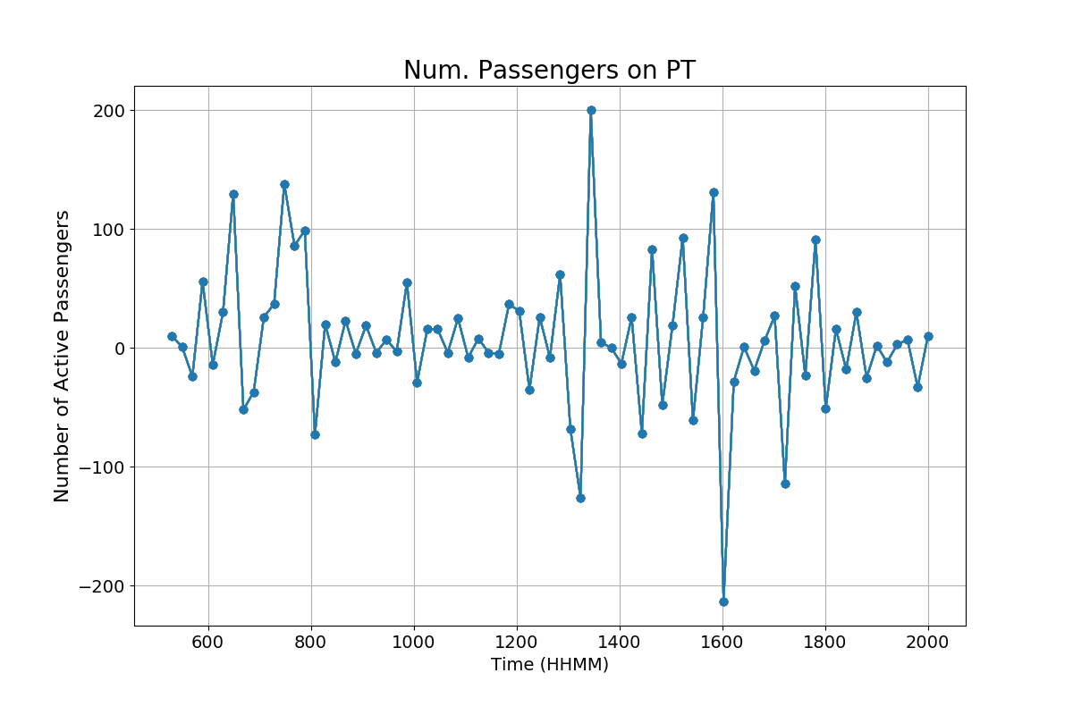
The graph on the left shows the number of commuters who have tapped on minus the number of passengers who have tapped off. While it plausible that this number might be positive at the end of a day (if, say, some number of people do not tap off), there's no good explanation of why more people tap off than there are people currently tapped on.